| Land Cover
Investigation Tests
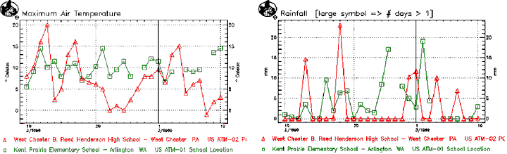
(Given data
from the GLOBE data archives) GLOBE Data for:
1) West Chester
High School, West Chester, PA
2) Kent Prairie Elementary School, Arlington, WA
| School |
Latitude |
Longitude |
Elevation
(m) |
| West
Chester High School |
39.9662
N |
75.5977
W |
338 |
| Kent
Prairie Elementary School |
48.1832
N |
-122.1198
W |
157 |
(Present problem
requiring use of GLOBE data archives)
West Chester High
School and Kent Prairie Elementary are two GLOBE schools that
have similar MUC codes. However, locations that have the same
MUC may or may not have similar weather patterns. Recently,
the two schools have decided to collaborate on a plant-growing
science project and you and a small group of students have
been asked to write the final report. The project involves
finding which school has more favorable conditions for plant
growth. Given air temperature and rainfall data from both
schools your job is to help determine which environmental
factors are most important to plants growing at the two land
cover sites.
1) (Plan Investigations:
Pose relevant questions) Look at the GLOBE data above.
Think of two questions you might ask regarding the data. A
sample question might be "Is there anything unusual regarding
air temperature between the two schools considering they have
the same MUC code?"
2) (Interpret
GLOBE Data: Infer patterns, trends) One of the students
in your investigation group, Martha, suggested that finding
trends in different sets of data is sometimes helpful for
analysis. What trend do you see regarding the air temperature
for West Chester High School? What trend do you see regarding
the rainfall for West Chester?
3) (Take GLOBE
Measurements: Use quality assurance procedures) You have
watched some of the students at your school collect GLOBE
data and have been impressed by how thorough they are. As
a check, are there any data that you suspect might be due
to a measurement error? How can you tell? What would you tell
these students to insure that this doesn't happen again?
4) (Analyze
and Compare GLOBE Data: Identify data components) Another
student in your investigation group, Antonio, mentioned that
finding trends between different variables can be a very useful
part of analysis. What is the relationship between the two
variables given? For example, if rainfall increases, what
happens to the air temperature?
5) (Interpret
GLOBE Data: Create multiple formats to represent data)
Using the maximum air temperature graph, break the graph into
four 1-week groups. Make a table showing the range in temperature
for each week at each school. Compare the range in temperatures
between the two schools. How may this table you just created
be helpful in finding which school has more favorable conditions
for plant growth?
| Max
Air Temp (Celsius) |
Week
1
|
Week
2
|
Week
3
|
Week
4
|
| West
Chester |
17
|
8
|
10
|
16
|
| Kent
Prairie |
8
|
7
|
4
|
7
|
6) (Interpret
GLOBE Data: Create multiple formats to represent data) Using
the rainfall graph, create a similar table to the one you
made for question 5 but find the total amount of rainfall
for each school for each week. Compare the amount of rainfall
between the two schools. How may this table you just created
be helpful in finding which school has more favorable conditions
for plant growth?
| Rainfall |
Week
1
|
Week
2
|
Week
3
|
Week
4
|
| West
Chester |
15mm
|
23mm
|
22mm
|
17mm
|
| Kent
Prairie |
12mm
|
29mm
|
43mm
|
27mm
|
7) (Analyze
and Compare GLOBE Data: Identify data components) When
analyzing graphs there is a lot of information to be aware
of. What does it mean if there is a break in one of the graphs?
If you are looking at the maximum air temperature graph, what
does the line between two data points mean? If you are looking
at the rainfall graph, what does the line between two data
points mean?
8) (Plan Investigations:
Set up another problem) Choose another school with the
same or very similar MUC code from the GLOBE database and
compare this school with the two schools above. What trends
do you see from this new school? In other words, how is this
school the same and/or different from the two schools given
above? What other land cover variables might you look at to
tell you more about the environmental factors at each school?
Why did you choose these variables?
9) (Communicate:
Compose reports to explain or persuade) Using the data
analysis you have done, write a short report (1 - 2 pages)
that summarizes your findings and explains which school site
has more favorable conditions for plants. Keep in mind that
not all plants require the same environmental conditions for
growth. Be sure to support your conclusions with data you
have analyzed and suggest other data that might be helpful
for further study of the land cover sites.
|