| Earth
Systems Investigation Tests
The growing season
for a native crop is the amount of time necessary at suitable
air temperature and soil moisture levels for growing to occur.
In an effort to increase the food supply in overpopulated
areas, a group of scientists have proposed trying to plant
a crop in several places in the world that have similar environmental
and climactic conditions as the area where the crops are native.
As a preliminary study, the scientists have been looking for
areas that have similar air temperature and soil moisture
conditions. Using the graphs and data above and assuming all
other conditions are equal,
a) answer all of
the following questions
b) write a short
report (about 1 page) that discusses the possibility of planting
the new crop in any of the regions - Heath, Barron, or Kinninmont.
Make sure you support your conclusions.
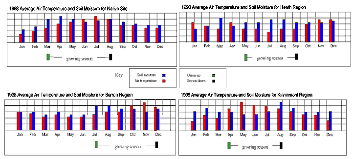
1) (Plan Investigations:
Pose relevant questions) Look at the graph for the native
site above. Think of two questions you might ask regarding
the data that are related to finding other sites that have
similar conditions. A sample question might be "At what point
during the year does it look like spring is beginning?" Make
sure you also say why you think the answer to your two questions
might be helpful to you.
2) (Interpret
GLOBE Data: Infer patterns, trends) One of the students
in your investigation group, Samantha, suggested that finding
trends in graphs is sometimes helpful for analysis. Looking
at the bar graph for the native site, what trend do you see
regarding the air temperature?
3) (Interpret
GLOBE Data: Explain data & relationships) Looking again
at the bar graph for the native site, mark where you think
each of the four seasons begins and ends. For example, mark
"S" for the beginning of spring, "Su" for the beginning of
summer, "F" for the beginning of fall, and "W" for the beginning
of winter. Make sure you label each of your marks.
4) (Take GLOBE
Measurements: Detect errors; Use quality assurance procedures)
The air temperature and soil moisture data shown in each of
the graphs are monthly averages. To find the monthly averages,
data was collected by students taking measurements on each
day of the month and then calculated then calculated at the
end of each month. Since it is always important to show accurate
data in your graphs, what are two possible sources of error
you can think of in the above method?
How would you make
sure that these errors did not occur if you were taking the
measurements and calculating the averages?
5) (Interpret
GLOBE Data: Explain data & relationships) Another student
in your investigation group, James, mentioned that finding
relationships between different variables can be a very useful
part of analysis. Looking at all four of the graphs on the
first page, what relationship do you see between the beginning
of the growing season, or green-up, and the air temperature?
6) (Interpret
GLOBE Data: Infer patterns, trends; Explain data & relationships)
For the three candidate regions (Heath, Barron, and Kinninmont)
mark where you think each of the four seasons begins and ends.
For example, for the Heath region mark "S" for the beginning
of spring, "Su" for the beginning of summer, "F" for the beginning
of fall, and "W" for the beginning of winter. Once you have
marked each map, fill in the chart below that compares each
region's beginning and ending temperature and soil measurements
to that of the native site. Use "+" if the measurement is
more than the native site, "-" if the measurement is less
than the native site, and "." if the measurement is the same
as the native site.
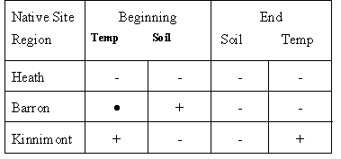
7) (Analyze
& Compare GLOBE Data: Identify similarities and differences)
Using the table you just created, which of the three possible
sites (Heath, Barron, and Kinninmont) looks like it has a
growing season most similar to the native site?
In determining
a possible site for growing non-native crops, what additional
information would you need to make an accurate recommendation?
8) (Plan Investigations:
Specify measurements to investigate) Looking again at
the marks you put on each graph that show where you think
each season begins and ends, list two additional types of
data in the GLOBE archives that would be helpful to determine
the beginning and ending of each season.
9) (Communicate:
Compose reports to explain or persuade) Using the data
analysis you have done, write a short report (about 1 page)
that summarizes your findings and explains the pros and cons
of each site (Heath, Barron, and Kinninmont) based on its
similarity to the growing season of the native site. Make
sure you discuss additional information that you would need
to make a more accurate judgement on each of the sites. Also,
be sure to support your conclusions with the data in the graphs
and the analyses you have done while answering the questions.
|