 |
 |
|
|
|
|
PERFORMANCE TASK STUDENT RESPONSE FORM TASK: S/SS1 — River Planning Grade 8 Student Name: _________________________________ School Name: _________________________________ School Code: _______ GENERAL INSTRUCTIONS Write your name, school name, and school code on the lines above. Do not begin this test until the directions tell you to do so. The purpose of this task is to determine where, how high, and for what purpose (flood control, recreation, hydroelectric power, etc.) to build a dam. You will have a total of 45 minutes to complete this task. You may use up to 20 minutes to complete the group work, found on the first two pages of this form. When you finish the group activity, someone from your group should tell the facilitator. Then you may open this form and follow the directions inside by yourself. Your group should have the following materials:
GROUP ACTIVITY
Record information from your group’s tests in this chart.
Make sure that each group member’s name appears on the map. One member of the group should insert the map into his or her response form when passing in the completed form. When you are finished with the work on this page, one member of the group should tell the facilitator that your group has finished its group work. Then go on to the individual work. Remember that you must work alone on those pages. You may not discuss the questions or share information.
INDIVIDUAL ACTIVITY 3. After reviewing the work your group has done, where would you place the dam and how high would you make it? Why? 4. What social, environmental, and economic impacts would the location you chose for the dam have on the surrounding community? 5. Describe concerns you would include in an environmental impact statement for dam sites other than the one you selected in question 3.
Be sure one member of the group inserts the map inside his or her form for collection. River Planning Map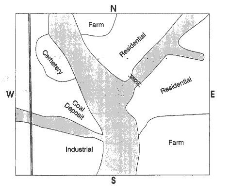
|