|
Grade 5-8 Performance Task
Contributed by: New York State Education Department (NYSED)
NYS Alternative Assessment in Science Project (1996)
Student #3
Task:
Using data in the chart below, the student will determine
the location of the epicenter of an earthquake.
Materials:
Background:
When an earthquake occurs, scientists need to determine
the location of its epicenter as soon as possible. The epicenter
is the point on the surface of the Earth directly above the earthquake.
Measurements from at least three seismographic stations allow scientists
to locate the epicenter.
Directions:
The data in the table are the delay times between
the S and P waves from an earthquake to three stations (A, B, and
C.)
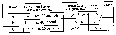
1. Find the distance of each station from the earthwuake
using the delay times between the S and P waves and the graph on
the next page. Record these distances in the table.
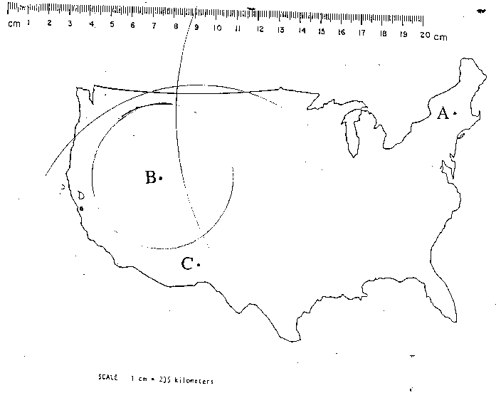
2. Locate the epicenter of the earthquake on the map
on the last page. Calculate and record your map distances in the
table. Indicate the epicenter location with the letter X.
The scale of the map is 1 cm = 300 kilometers.
3. In the space below, describe 3 procedures you used
to locate the epicenter of the earthquake. Answer in complete sentences.
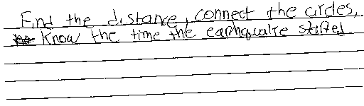
Figure 2
|